THE BOSTON & ALBANY RAILROAD
_____________________

COMMENT
On massDOT's East-West Passenger Study
By Bruce Hain November 2020
_________________________________________
______________
____________________________________________________
To download and view the file in Google Earth go HERE.
(You must get a ProBoards Username)
____________________________________________________
BACKGROUND AND CONTEXT
The Boston & Albany Line was a great achievement, and Wikipedia says it was claimed to be the most expensive US railroad ever built at the time, circa 1840. There have no doubt been improvements, judging by a few broad curves and big spiral offsets now extant, and the line as a whole is brilliant in achieving the gentle grades that it affords.
A 1952 New York Central timetable shows the quickest time for Boston-to-Albany service was carded at four hours and fifteen minutes. The fastest trip today is four hours and forty-five minutes, going west, and five hours and ten minutes, going east - and it's difficult to understand why. A Google search suggests that the time to make the trip by car today would run about two hours and forty minutes - although the route skips Worcester, Springfield and Pittsfield; and the hoped-for advantages of getting directly in and out of those and the terminal cities while avoiding traffic, are not considered. It should be the aim of any study involving actual changes in basic alignment (so-called short cuts) to make for scheduling roughly competitive with that, and to include at least the three existing important stops.
Reaching Albany proper today would necessarily be by means of the Castleton Cutoff - with the aim of reopening the abandoned Albany Union Station. Your commenter has studied deeply an upgrade using the Delaware & Hudson Line along the west shore of the Hudson River, which proved too obstructed and slow, leaving a trans-Hudson tunnel as the only feasible option for getting to Albany proper, this improvement being an absolute necessity if competitive rail service from the south or east or anywhere else is to be had. Connecting the station is readily achievable, involving little in the way of curves and obstructions in its immediate area (less than before curve-wise) and little demolition caused by the need to remove existing objects - except parking in the direct area of the station, which can easily enough be built back with improved aesthetics.
By way of explaining the apparently off-topic subject matter: It's necessary to think of the Boston & Albany as fulfilling in modern times the mission that its name implies (though details of alignment west of Springfield are not actually covered here) because in planning for a modern passenger system, the most easily upgradable option for getting to Chicago would include the New York Central Main Line as far as Buffalo, whereas the option of building a new Pennsylvania Railroad from scratch remains a rather remote possibility at this point. The Boston & Albany then, would form a crucial and integral part of any reasonably foreseeable service to Chicago and the West.
In terms of the percentage of upgrading that requires tunneling the Boston & Albany has the New York Central beat by some tens of miles. It requires going through a lot more land mass for purposes of abbreviation, despite the big difference in the two lines' length, and though the Upstate New York terrain is known for being steep. There are advantages to express tunneling though, in areas with the types of development concerned, and in this case the resulting zig-zags are at-least-mostly tangent. The Boston & Albany is by far the most tunnel-intensive per linear foot of any passenger upgrade your commenter has ever considered.
A studied and careful assessment would envision a complete B&A upgrade for modern passenger service as involving five long, high-speed tunnel abbreviations, achieved through modern, single-bore, double-track tunneling as seen in Europe, Japan and China. This is the type of alignment suggested here - as against the Mass Pike alignment discussed in the documents - since it would offer speedier schedules, and would actually be less expensive to build, for reasons discussed below. Four of the tunnels would be located in Massachusetts, and one in New York.
Here you will find illustrated some preliminary designs involving four of the five such abbreviations contemplated for the B&A, located in the areas around Palmer, Worcester and Framingham, with descriptions of some of their projected characteristics.

FOUR PASSENGER EXPRESS TUNNELS
THE LOW HANGING FRUIT appears to be Commuter Service, Springfield to Palmer - as a means of developing passenger revenue for the line's upkeep. It's ready for four-tracking up to seven miles out - then you have a 30-foot-wide bridge at Stony Hill Road, and the same at Boston Road - and eventually the Quaboag River Bridge - plus the four little-used grade crossings noted in the documents.
Four tracks means with the outside tracks 40' apart - which is the most common configuration in American practice - and without the forty-foot wall. I know of three recent passenger studies that use the 40-foot-tall, 4-foot-thick wall thing as a gimmick to declare infeasibility in the documents - always of the best possible alignment.
Your commenter envisions eight stations with side-platforms, spaced about a mile apart, and extending east to Boston Road (about ten miles) - with the five-mile stretch thence to Palmer - as being part of this Commuter Scheme. It's certainly more constructable than Springfield-to-Holyoke or Northampton, where a lot of heroic upgrading is necessary to achieve any passenger draw.
There are now some pre-fab platforms available, which of course require solid grounding, that have been used successfully by the Long Island Railroad on a rather more-permanent-than-pre-fab basis. The platforms might be useful in determining whether any given station is likely to prove helpful in eventually generating income.
If CSX isn't capable of maintaining their property to an acceptable standard then the state should do it for them, taking equity in the form of property ownership as payment. I'm not saying they need concrete ties for their freight operations, but the tracks along the B&A are so out-of-line it takes quite a while to determine the headings in Google Earth. Old rail lines almost always have "0" in the 2nd decimal place so it should be easy.
CSX should be required to refrain from insanely heavy axle loads, and all rolling stock must be adequately maintained. It's time for the state(s) to step in and lay down the law. And that applies to the "symbiotic relationship" between freight carriers, the FRA and the rail planners holding your state agencies in thrall. The state has the power to do that, on a basis of reasonableness alone.
IT SAYS SOMETHING that the only definitive drawing in the entire document shows a preferred pie-in-the-sky track spacing of 30 feet. (I suppose that would make for practicability of the 40' wall.) These schemes are designed to make for impracticable expense and bulkiness in relation to existing property rights, and to skyrocket the price of special trackwork while requiring slower speeds.
IT IS PATENTLY ABSURD that the freight carriers et al hold over the state the threat of damage and fatalities DUE TO THEIR OWN NEGLIGENCE as a means of getting their way, and it's a "pattern" within the meaning of the RICO statute.

EIGHT PASSENGER STOPS RUNNING EAST FROM SPRINGFIELD
THE STATION AT PALMER is good for a commuter service endpoint, indefinitely: with or without its original, partially-raised platforms about a foot above the tracks; and it would feed a good number of passengers from the intermediate stops to any regional service that might be planned. It appears though that the old bridge over Bridge Street, despite its history and unique design, has outlived its usefulness. In this case a significant amount of relief from a number of aesthetic and technical issues could be had if the tracks were to run UNDER the bridge.
With the crossover junction at a level of about 310' (My current scheme has it at 307.5 - if the elevations in Google Earth are to be believed.) there would be ample room for double-stack freight. A road bridge about five feet higher than the existing one would still be five feet lower than the road's intersection with Main Street to the north, and none of the four rail approaches would be adversely affected by any significant increase in their rate of change in elevation.
The project would comprise a large geographical area, at the station and along the concerned rail rights-of-way, including the Quaboag River Bridge: renewal of which would be undertaken within the same project timeline. While having four tracks at this point on the B&A would be preferable, the question of whether the expansion of earthworks along the five miles to the west would be prohibitive has still to be answered. A scenario of having three tracks, with future plans for four, would have the bridge rebuilt for four tracks in any case.
The north side of the Palmer station would require an additional island platform, to bring train capacity to a serviceable standard for the future: with two platform tracks at Palmer on the B&A Passenger Line. The issues of what gets bridged over, and how to achieve an integrated, landscaped design for it - that doesn't upstage the original station - are important questions. The designing would also include a new, wider road bridge, and a second bridge at the Main Street crossing.
Changes at the station would not scream of historical inaccuracy (or slavish insistence on it) given a competent process of design, spread out over a decent timeline, with detailed and deliberative planning. The original B&A shed on the north side can be replicated exactly, and stone structural elements of the old railroad bridge could be repurposed to make for several commodious stairs to reach the two new side platforms flanking the station at a lower level: totally in keeping with the original, deeply stylistic and luxurious intentions of the architect.
Given sufficient will and financing (and the required number of tracks) alterations could be extended to the crossing of Main Street, to provide a more direct and commodious bridging of the tracks there, with stone available from the old bridge for decorative walls where needed, and some landscaping. The new grading scheme would result in plenty of clearance for double-stack freight around the Main Street Bridge so that a more close-to-level grade of the roadway could be had. The result would encourage flourishing development and commerce in this area near the station, that has been held in check heretofore by presence of the sharply angled crossing. And there would be room for a few new buildings as well.

PALMER OVERVIEW (UP IS SOUTH)
You might want to talk to a traffic engineer before inking any contracts. The whole is envisioned as having all the new construction at a level not much higher than the tracks are now, to avoid upstaging the station. While it's assumed the new platforms themselves would have sheds, with roof line located some seven or eight feet below the current platform level, the stairs from Bridge Street (right) might be best without any protective roof structure. The stairs shown at Main Street (left) are distant enough so as not to interfere with the station sightlines, and might incorporate a more elaborate roof structure, concentric with the curb as shown. The two B&A platforms are shown as being about 600' long, which appears to be the original intended length.
The four-track alignment to the east seen at the extreme left of the picture would be achieved by continuing the next curve, located 1.33 miles off the picture to the left, so its central angle is increased by 5/100 of a degree, thus jacking the whole alignment some distance to one side. This would be necessary to avoid over-nearness to the newer annex building with the grey roof, which has been added to a probably-originally-industrial building property on Church Street. (The centerline of the nearest track is shown as being 24' from the annex building's nearest corner.) Since the new street configuration would provide a lot of empty curbline for possible commercial development - alongside, as well as over the tracks - it's probable a deal could be struck with the owner of the said annex that would increase the property value as well as allowing a less abrupt reverse curve than that shown on three of the mainline tracks, allowing for higher speed and stability.
The issue of isolating Water Street by having it pass UNDER the proposed Bridge Street Bridge and thence through a circuitous hairpin alignment involving a left turn across traffic and a hill - to finally reach the point where it currently intersects with Bridge Street, could be nicely addressed by building a third new bridge across the tracks at Valley Street (not shown) providing access to South Main Street by a direct and level route. The Water street configuration as shown in the area of the Palmer DOT (upper right) is not very refined, but would offer an option for parking a few cars under the bridge.

PALMER CLOSE UP
The fancy stairs with central landing have been located to take advantage of the area under the big gable, where there is no outside door. A bench centered with its ends extending under the two giant mullioned windows there would face the landing, with its last two steps, and make for a nice place to wait for arriving passengers. Not knowing the rules of the road it occurred to me a flashing-yellow-light might function safely to enable passenger drop-off on a new Bridge Street Bridge, whereas a left turn would likely not be possible on Main Street at the analogous location. Given a desirable configuration within the station, or below the surface and adjacent to it (the triangular area at center between the platforms only, barring availability of any other space) passengers arriving from Bridge Street could access the side platform and station interior by way of a tunnel connected to the stairs shown on the island platform. An elevator is shown between the two stairs.
Both platforms are shown as being 12.5' wide, although some few additional feet might be afforded by having the side platform extend under a slight overhang of the station walkway above it, which might involve columns, though probably not period ones. There are several advantages with having access to the elevators and tunnel confined within a securable station building, but providing for vertical and step-wise access to a tunnel some 30' below the main level of the listed station would require a lot of space, and be dependent on the particulars of the original or revised floorplan. Thankfully it would not be considered 'practicable' to provide elevator access at Bridge and Main streets, so the mechanized means of vertical conveyance could all be securely confined within or adjacent to the existing station building, in a controlled environment.
No fancy stairs-with-landing analogous to those on the north are shown at the approximately-300-foot side platform on the south. (up in the picture) The platform would be accessible through a portal from within the station, as with the 600' platform on the north, but the portal would emerge at the near side of the platform, rather than passing under the central landing of the stairs as on the north. The broad and strangely-angled stair at the platform end was an afterthought and might assume various positions or configurations. Stretched to a commodious length and enclosed with a secured entrance (preferably not at odds with the context) it might serve as a sort of grand entrance to the platform, which might be enclosed as well, with glass platform barriers, and make for a linear dining experience for viewing trains, along with a round pavilion at the merging end of the two platforms, and the triangular area between them.

BIG REVERSE CURVE WEST OF PALMER
IT'S PUZZLING how the big reverse curve west of Palmer (labelled 'Monson' in the documents) is cited for abbreviation, albeit an infeasible one. This is the only one of your planners' proposed abbreviations that currently enters into the plans put forth here, because my ideas about upgrading would take express passengers off the existing main line for most of the way between Palmer and Framingham. The reverse curves in question (Monson) have a 4000' radius on the east and a 3500' one on the west. (right to left) That's good for 90mph given suitable alignment and upkeep - so it's difficult to see what planners mean by suggesting a tunnel there (the only way to abbreviate it) as it would set up a big conflict with the property owners. Any competent engineer would probably locate it the same way today, though it's possible further curves to the east before the Quaboag River might be ripe for straightening. While this reverse curve may appear restrictive to the uninitiated eye on a map the configuration is in no way deficient.

FENTONVILLE PORTAL
It was seen as best to extend the tunnel about a quarter mile to the west versus the more instinctive approach of bridging the meandering river and entering tunnel configuration where the new line would cross the Dunhamtown-Palmer Road, off the picture to the right. This would help to make the line's presence imperceptible at the nearby houses there, and make for additional high cover in the sparsely populated areas to the east. Coming from the left, the four-track line with passenger tracks being the bottom two, begins to divide at Baker's Self Storage through means of a spiral segment of the two passenger tracks, bringing the tracks to 20' apart at the parallel tangent segment. This spiral starts near the closest point to a diminutive el - part of a large and visibly well-maintained facility for vehicles on the self-storage property, which is 12.6' from the southernmost track on center as shown, i.e. too close for the speeds contemplated. Trains on that track would be accelerating through the following ten-thousand-foot-radius curve, which passes through the portal, to the 150mph tangent of the 9.3-mile tunnel.

FENTONVILLE-BROOKFIELD TUNNEL
The 9.95-mile Fentonville-Brookfield abbreviation takes 4.45 miles off the existing route while enabling sustained high speed as against the old line, which takes quite a while to traverse. On entering the tangent section at Fentonville the route only alters its course once - by nine tenths of a degree - before reaching East Brookfield, a distance of 12.8 miles.

BROOKFIELD PORTAL OVERVIEW
The grade here is the steepest one on the said tunnel line at 1%, and extends into the tunnel about 500'. It would help to brake trains going east, to make them less intrusive, and it's hoped that linearly propelled and retarded trains would be the norm by that time. The main grade of the tunnel is about .06%. Going east the line alters its course at a high spot west of the river by nine tenths of a degree, to that of the existing tracks, flying over them and expanding the existing right-of-way to the north, using the old centerline along the succeeding 2.6 miles to East Brookfield.
It's possible a station could be arranged where the line crosses Fiskdale Road (left of center) in the midst of the descending vertical curve to the tunnel, if only as a sort of bribe to gain acceptance for the intrusiveness seen at lower left. While much experimenting was done to get an optimum alignment, there is a garage structure about 60 years old on location of the proposed tunnel portal that would have to go. The station, while possible, would be awkward located over the road, and more so given additional station tracks to alleviate the obstruction. A better spot for a Brookfield station, though not in Brookfield proper, is located along the proposed four-track segment of the old alignment, where it looks like a station may have existed at one time.

EAST BROOKFIELD AND ENVIRONS
The high-speed passenger line would pass under the parking lot of the CSX car rack facility in a short tunnel and, running thence east at grade for one mile, dip into another lengthy tunnel, emerging near Worcester. The now-defunct Spencer Branch has been realigned to meet the tracks of the existing main line, along 2.6 miles of which its revived passenger service might run, albeit in what might be viewed as retrograde, to a purpose-built platform at the East Brookfield station (left) making the branch 3.6 miles long in total. While parking at the Spencer station as shown is not contemplated (The line is truncated, and would not reach to the old, central Spencer station.) an additional stop with minimally intrusive access for cars might be provided near the little league diamonds visible directly south of Spencer quite near the single track. Both stations would have single side platforms and level boarding integrated with the local topography.

EAST BROOKFIELD
The East Brookfield station is seen as beneficial because of the populated places around it that could be served, including possible service from the west by way of West Warren, Warren, West Brookfield and Brookfield - to mention only places on existing trackage - at least one of which has an existing station. Truly if they were interested in making a go of it the protagonists would have arranged for service at some of these places by now. The main platform is shown as being 800' long and 25' wide. Reviving of the Spencer Branch is seen as providing a convenient first stage in introducing local service.

SOUTH SPENCER
It's possible that attempts to bring service to both Spencer and South Spencer would be fraught with people who don't want hangouts and trouble. It's important that stations be orderly and secure, and there are a number of ways to insure a secure situation, firstly by controlling access to the station interiors, through a special pass. Because of these stations' remoteness, this would mean that at least the South Spencer platforms would have to be enclosed, with full platform barriers, preferably glassed-in to the extent possible. The two South Spencer platforms are shown as being 10 feet wide and 50 feet long.
Access might best be controlled by members of the respective communities, with the service provider devising the means for controlling access using electronic passes, while members of the community who use the service regularly would take turns at issuing time-sensitive passes for visitors. The stations at Spenser and South Spencer contemplate a new approach to Transit Oriented Development - i.e. walk to the train - and truly their property values would rise - but the crucial thing here is to prevent undesirable changes brought by the new service.
The local service, connecting the relatively populous Spencer to the main line, would establish a good precedent for extending local service to the west, thus feeding the regional and high-speed ridership.The South Spencer station and stairs could be unobtrusively lit at night, and possessed of the ever-increasing effectiveness and economy of electronic surveillance. Parking facilities are not foreseen at South Spencer. Though the stair to the eastbound platform is located at an intersection (not possible to see in the picture) the only development likely be tolerated would be a short unpaved turn-off near each of the stairs. Careful management of the property could prevent the advent of any changes in the rural character of the community brought by the station, that are not wanted.
It was discovered recently that the bridge seen as being flanked by the two station platforms here is a 3-track bridge. The 3-track configuration is vastly preferable for obvious reasons if you're going to have a station. Construction of the elevators shown would be extremely expensive as compared to their likely volume of usage - and disruptive to the bridge as well, probably requiring that the bridge be rebuilt in the process. Using roller coaster technology to provide linear elevators - protected, securable and concentric with the stairways but having the requisite difference in grade from them - is contemplated, but is difficult to draw and I didn't want you to think I was insane. It would certainly be cheaper than the elevator project.

SPENCER-WORCESTER TUNNEL
The 10.64-mile Spencer-Worcester Tunnel line would take 5.59 miles off the existing configuration, and enable quick passage with its tangent and broadly curving geometry. The tunnel curve is shown as having a centered radius of 30,000 feet, whereas that of the reverse curve above ground to its east is shown as being 15,000. The length of the main bored section is 7.6 miles.

APPROACHING WORCESTER
The Spencer-Worcester Tunnel makes a heroic entrance west of Downtown Worcester, emerging from the side of a hill as the ground falls off in front of it. Next, a high-level bridge over the corner of the industrial buildings of Bulbs.com, then over the existing line twice, forming, finally, the passenger tracks of an upgraded four-track line situated to the north of a new center line. (You may notice the new tracks overshoot the existing line at the top of the picture, and that's because I originally thought they would want to pass under it there, having failed to notice the low lying bridge - but that would be impossible. The reverse curve directly east of the Curtis Ponds Bridge then would be eliminated with the aerial approach, and the broad curve reversing beyond the tunnel portal (R=15000) would be situated somewhat farther from the existing road, and the residential property behind it.)

WORCESTER-WESTBOROUGH TUNNEL
The Worcester-Westborough Tunnel concept is blessed with fortuitous topography and it would save a lot of time. The land rises abruptly quite near the tracks in Worcester, making for plenty of cover under a few residential buildings there. Descending in a 1.63% grade over 11600 feet to 55' feet below the water's surface (300' above the datum plane) at an island under which a good part of the tunnel's section would pass, the line levels off, then emerges dramatically again, out the side of a hill, amidst the bucolic countryside. The reverse curve here is similar to the one located west of Palmer and discussed above, having a 3500-foot radius on the new part, and a 4500' one on the old, the latter having a much shorter central angle. Several efforts were made to modify the reverse curve configuration over some months, by use of more direct and tangent alignments, but they were all problematic due to their intrusiveness. This alignment makes for a dramatic ride, out of the tunnel and over a low-slung curving viaduct, while gradually slowing to meet with the existing tracks.
The tunnel line is 6.95 miles long and takes 2.63 miles off the existing configuration. The tunnel proper runs 5.92 miles. As with the rest of the B&A, the existing line is beautifully laid out in this segment, and designed for three tracks throughout. It is suggested the Westborough station be moved to its original location or thereabouts - to get the benefit of more passengers - and because it appears a number of these stations have been built with the aim of restricting the right-of-way to two tracks - while much of it was at least three at one time, with the bridges so-configured. The conditions and giant grade crossings of the B&M trackage going towards Boston are an international disgrace.
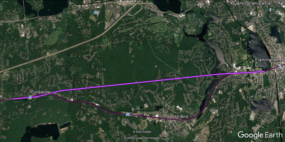
CORDAVILLE-FRAMINGHAM TUNNEL
The surmised-as-5.6-mile Cordaville-Framingham Tunnel would provide a speedy bypass of Ashland and arrive in Framingham just west of the instant giant grade crossings. It is the least developed of these four tunnel plans, with surmised points of intersection and no particular headings. It would also be likely to become the most politically disruptive of the four. The idea is to descend from the west under the existing right-of-way as far as possible starting at a point (left) where the four tracks would necessarily be propagated to six so the express tracks could be made to diverge. According to my calculations as I recall it's possible to get at least 200' of cover under nearly all the houses that the line would cross beneath or near.
Alternatively there would be great advantage realized by introducing complete grade separation in Ashland and Framingham, as the horizontal alignment there is largely tangent and broadly curved.
ADDENDUM
SEVEN POTENTIAL CORRIDOR REALIGNMENTS OF THE PROPOSED ALTERNATIVE 5
There are seven proposed realignments described vaguely under Alternative 5. Your commenter has attempted to delineate them as far as possible with some degree of exactness, to see what their physical properties might be, and what consequences their realization might entail. The proposed realignments are addressed as Shortcuts 1 through 7 below, and are numbered as running east-to-west.
Shortcut 1 - Auburn-Oxford-Charlton: Shortcut 1 is the lengthiest of the seven proposed realignments at about 3.2 miles, and runs through mostly-level terrain along the north side of the Massachusetts Turnpike. The exiting of traffic from and reentry to the existing line would present problems due to its two-track configuration in hilly terrain (reduced to one in many places) where adding additional tracks has not been addressed, requiring local traffic to somehow be shunted aside while the faster trains pass to and from the Shortcut.
This Shortcut establishes a dangerous precedent as shown in a number of drawings, where an apparently desired but not otherwise documented or described extension of it is shown bypassing its connection to the old right-of-way on the east, and thereby bypassing the great passenger station at Worcester, which has already had its train capacity and amenities gutted and debilitated, perhaps never to be restored.
This is a modus operandi seen in extremely numerous cases throughout the US in the decades since World War II, where such great stations from the golden age of rail expansion - offering speed and train capacity impossible to duplicate today - have been debilitated, ruined and demolished. (See St. Louis, Cincinnati, Albany, Troy, Detroit, Birmingham, Buffalo, Joplin, Kansas City, including three credible attempts to get Grand Central demolished in my lifetime.) Amtrak has shown a disgraceful degree of complicity in this.
My viewing in Google Street View shows Worcester to possess old buildings of amazing quality and extraordinarily high quantity from the 20th Century and before, placing it in a special category of extraordinary and irreplaceable assets that must be preserved as part of the American experience. The existing Worcester Station is essential to that goal. And besides: The existing Worcester Station is the best bet for achieving high passenger draw and handling it expeditiously. It would further be achieved by offering passengers good service from the towns along the old line where service has been abandoned - feeding the big interchanges such as Worcester - but I doubt that is what your consultants and engineers have in mind, because, the frustrating precedent shoved in our faces - and these documents - belie their true intentions. This Shortcut 1 must be opposed with all possible force and urgency, for those reasons.
Shortcut 2 - Charlton: Shortcut 2, among others, is a nonstarter, and it's difficult to imagine it not being clearly and intentionally so. The approximately 1.5-mile route cuts across a well-to-do, wooded residential area and private school campus, and is elevated in it's configuration to some significant degree, making it the more intrusive and undesirable as seen from the ground. A number of seizings and demolitions would be required in addition to the properties that will be otherwise ruined as against not having the shortcut in close proximity. The alignment bypasses Rochedale, set at a fairly broad curve between two long tangents on the old line, where a station might be set up - and no doubt previously existed - to serve the local populus and feed passengers onto the regional and proposed high-speed services. Your planners could not but fully expect what would happen in terms of local uproar and litigation if construction of Shortcut 2 was to ever be attempted.
Shortcut 3 - Charleton Depot: Shortcut 3 originates in Charlton Depot, a place where a station might logically be expected to serve local passengers, and to feed regional and proposed high-speed services thereby. Here the original line cuts around the perimeter of a rocky hill in a long 1200-foot-radius curve ( good for 45mph) encompassing about 90 degrees. Planners propose replacing this with a surmised 5000-foot-radius curve, cut or tunneled deep into the rocky wooded hill in this well-to-do residential area. The realignment would be about 4700' long. At its deepest your commenter surmises the tunnel or cut would be about 110' feet below the surface at top-of-rail, and according to the conditions encountered might necessitate a substantial broadening of any cut towards the surface elevations, making for a big gash in the landscape. Whether tunnel or cut, the "gash effect" would still obtain at the ends of the new alignment, where any increase in radius would result in bringing the line closer, and onto, the properties - particularly of the fancy old houses found close to the line in Charlton Depot, - with a proportional increase of intrusiveness accompanying any degree of expanded radius. Naturally the shortcut will increase the rate of ascent for eastbound traffic, to about 1.4%. It is unknown if the original well-liked gash is to be abandoned with advent of this newer better one. All told the proposal seems unlikely of realization because of its intrusiveness.
Shortcut 4 - Spencer: Shortcut 4 would probably be accomplished by constructing an approximately-4350-foot-long double-bore tunnel. But the places where the tunnel or cut comes level with the land would entail the same type intrusiveness encountered above, but worse: plowing directly through a number of houses and properties, the owners of which would likely be duly offended by the damages proposed and resort to litigation.
Besides the expense and likely litigiousness of these Shortcuts 1 through 4 - including possibly two double-bore tunnels (That's three miles of tunneling right there, involving a minimum of four boring operations: picking up the parts and reassembling the mechanism for each succeeding bore.) seen by planners as enabling a continuous higher speed through the area of something like 65 - not average speed - they fail to take into account that the route they're traveling so fast is taking them in the wrong direction. In getting from Boston to Framingham, Worcester, Brookfield, Palmer and Springfield, the route(s) chosen in modern times should have some relative bearing in the right direction. In olden times railroad engineers would attempt to select the lowest obstacle impossible to cut or bore through, and arrange a circuitous and therefore gradual approach on either side of it, called developing a grade. With modern capabilities this is no longer the only option, yet planners here are proposing developing the old skewed headings for high-speed travel, when they should be used for feeding the high-speed express service generally located elsewhere. As an example, the 7.6-mile Spencer-Worcester Tunnel described in the foregoing comment of November 19, would take at least 25 minutes off the time to travel all of these improvements, combined with the compulsory existing alignments - and probably for less money - especially given the long and potentially arduous litigation involved. (The said tunnel has the distinct advantage of being located nowhere at all through much of its length for some practical purposes.) The tunnel abbreviations would free up space for local stops on the existing line, whereas these questionably conceived upgrades would clog the existing line with two different grades of traffic, making it difficult-to-impossible to provide the needed local service. The old Boston & Albany is a thing of incalculable value, as much a part of the beloved local scenery as the scenery itself, and the practical part of that value lies in serving the communities along the line and feeding the express service. Any plans to alter it with "improvements" such as those proposed in this study should be subject to the severest scrutiny.
Shortcut 5 - East Brookfield: It's difficult to tell what the planners mean by proposing some kind of upgrade at East Brookfield. The curve there is fairly broad at R=2750' and has a substantial spiral offset. It is hemmed in by the somewhat soggy nature of the surroundings through which much of it passes - which could get litigious where alterations are concerned - and the relatively new CSX car rack facility (which appears little used) requiring an interlocking amounting to a single mainline switch that, according to American custom, must have a tangent section of a certain length facing the points - which tends to tighten the curve otherwise. I cannot see any advantage to changing much of it, but that's what you get when paid planners are permitted to conduct their consultancy without having to say what they're about. They should be about removing grade crossings in Framingham. (I mean, is there a big sewer or something? What about a siphon? The predicament of grade crossings in Framingham and Ashland is omitted from the study, and would probably afford a greater abbreviation of train schedules than a few of these big projects combined.)
Shortcut 6 - West Brookfield: The West Brookfield upgrade, far from instituting a stop at West Brookfield, seems to contemplate eliminating a rather speedy alignment including a curve with 2500' radius having long tangents on either side of it. Planners seem to be considering replacing same with another double-bore tunnel, of deeper draught and superior length to the ones already discussed here. As an example of an R=2500' curve that many are familiar with: the tunnel from New York's Penn Station to New Jersey (part of the greatest railroad engineering achievement of all time for a hundred years standing, till China) has such a curve at it's New Jersey portal, and by the time the last car's around it you're doing 80 (wonder of electric traction) though what with propaganda kinks and various and sundry, the speeds have lately slowed. The instant proposal is a silly waste and not worth the enormous cost of construction and maintenance - being as it is, located at one of the extreme nodes of the existing line's circuitousness and barely serving to abbreviate it - especially if you consider the needless custom of building two tunnels, each just slightly too small to accommodate two trains (whereas with a two-track tube trains can move at higher speeds) owning to "safety reasons" (see the series of deadly tunnel fires in the Alps) which are easily debunked as something that might be considered extortion in some circles.
Shortcut 7 - Warren: It's impossible to tell what this improvement would entail. Perhaps it's intended to move the tracks away from the carefully shuttered station so it can never be used again.
Bruce W. Hain
B.A. Music, Marlboro College, '79 Queens, New York
Sole Academic Qualifications November 20, 2020

If you want your comment to appear on Facebook, click the box next to "Also post on Facebook" at lower left. (It doesn't show up till you click or enter text in the text box.)